Lady Anne’s Way (LAW) is a way-marked long distance walking trail from Skipton in North Yorkshire to Penrith in Cumbria. Lady Anne Clifford was born in 1589 in Skipton Castle. After her father, George Clifford, third Earl of Cumberland, died in 1605, as the only surviving child she spent much of her long life in a protracted and complex legal battle to obtain the rights of her inheritance, which included the great castles of Skipton, Pendragon, Brough and Appleby. She regained the estate in 1643, and set out to restore her properties when the Civil War ended in 1649, when she was 60 years old. She died in 1676 and is buried in Appleby. You can read about her fascinating history here.
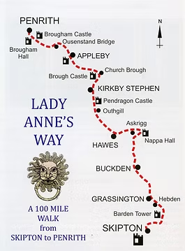
NAV4 Adventure organises a 75 mile race along the route, starting from Skipton Castle, passing Barden Tower, Grassington, Kettlewell, Buckden, Askrigg, Pendragon Castle, Kirkby Stephen and Brough Castle, and finishing at the Market Cross in Appleby. There has been a race in the past covering the full 100 miles to Penrith, however the final 25 miles contain a lot of road for not much added value in terms of scenery (or so I am told) so this section has been removed. There are also a few stretches where the race route deviates from LAW and travels along the Pennine Journey instead.
The event had three indoor checkpoints in village halls: Kettlewell (21m), Askrigg (38m) and Winton (60m), with lots of food, drink, warmth, toilets, and volunteers who could not do enough for you. There were a further seven vehicle checkpoints along the route, supplying water as well as safety cover and a friendly word of encouragement from a marshal.
In preparation for the race I had joined the official part-recce organised by NAV4 in early January, which was meant to cover the section from Buckden to Kirkby Stephen, with the option to drop out earlier at one of the meeting points with the minibus, I actually stopped at Mallerstang, my legs still tired from the Winter Downs 100 only a few weeks earlier. We had beautiful frosty weather with sunshine and a blue sky, the downside of the cold weather being that we could not drive over to Buckden due to icy roads. Instead we started at Worton, just south of Askrigg. It was a useful day, and also nice to meet some of the other runners. I then managed another two day hiking recce with my friend Gill, covering Appersett to Appleby with an overnight stop in Kirkby Stephen. On race day I became obvious that not having recced the section from Buckden over Stake Moss to Worton made that particular stretch a little tricky. Still, I have no real regrets as the logistical effort of doing that might not have outweighed the benefits anyway. Finally the route from the start up to Buckden was largely familiar to me.
The seemingly incessant rain since the start of this year had already prepared the ground for the mudfest that would be awaiting us. Heavy downpours in the preceding week as well as fairly consistent rain from mid-afternoon on race day until the next morning just completed the quagmire. It would be very difficult going underfoot, and this slowed many of us down considerably, with many runners slipping and falling multiple times.


My friend Andrew kindly drove me to Skipton for race registration at 8 am in the Town Hall. Having sorted out my finish and drop bags, and said hello to a few friends, there was time for a quick coffee before we all gathered on the start line in front of the Skipton Castle gates. It was overcast and dry, but the sky already looked like it would rain, so I decided on a last minute swap and replaced my insulated jacket with my waterproof. By the time I had sorted myself out we were ready for the off at 9 am. I started out running next to my friend Jen, but soon, as totally expected, she was just a tad too fast for me and I dropped back a bit. With such a small field (53 starters) we soon spread out and I found myself running on my own. I had a minor hesitation on Halton Moor when I could no longer see any runners in front of me, nor the path on the ground, and I briefly mistook the photographer for a runner and followed him 🤦♀️ before correcting myself and finding the way across the tussocks, down to the road and Barden Bridge and the first vehicle checkpoint (VP).
Onwards from Barden Bridge along the, to me, very familiar Dales Way to Grassington, then climbing up over Grassington Moor and Coniston Moor and past abandoned lead mine workings to Kettlewell, which is a higher route than the Dales Way takes and this looked quite unfamiliar to me. I was surprised that I had possibly never been on these particular paths. Perhaps a nice route to revisit on a warmer and sunnier day? It was quite foggy and by now it had started to rain. There was a lot of slippery mud underfoot here, giving us a foretaste of what much of the rest of the race would be like. I had joined forces at Grassington with a runner called David, and the time went by quite quickly as we chatted. We reached the Kettlewell checkpoint at 14:30. I put my waterproof overtrousers on here, had some tea and pizza, refilled my soft flasks and swapped my gloves over for dry ones. I managed to not sit down and was off out again into the rain (it would continue to rain until the next morning) fairly smartly, this time on my own.
From Kettlewell I took the path to Starbotton, crossing the Wharfe there and onto Buckden along the valley floor. Just before Buckden I met a family of turkeys on the path! At first I wondered if I was having hallucinations already 😆, it seemed a bit early for that. As I got closer I saw they really were turkeys, two adults and two youngsters. As I took some photos they came up closer and closer, until finally one of the young ones pecked at my finger which was quite painful, enough for me to drop my phone in the mud! I decided that was quite enough poultry encounter for now and moved on. I guess they were after food.

I ascended out of the car park at Buckden towards Cray and Stake Moss, the second of three climbs of some substance on this route. New terrain for me, I have been up to Buckden Pike several times but now I ignored that right turn and went straight on, due north, instead. Past Cray, along the road for a bit, saying hello to the marshals at another vehicle check point, then turning off onto a wide track. Apparently the Romans used this same route when moving between their forts in Ilkley and Bainbridge. And of course Lady Anne used it too. She did not travel light. Items of furniture, tapestries and even windows were taken from castle to castle, and whilst Lady Anne and her ladies-in-waiting travelled in coaches, with menservants following on horseback, many others (the entourage could be as large as 300) had to travel behind on foot. The Lady Anne’s Way guide book calls this stretch ‘bleak and inhospitable’, though it praises the views of Addlebrough. The writer of the book (Sheila Gordon) obviously was not thinking of foolhardy ultra runners who would not see any of the views whilst moving through the night.

Darkness fell once I started the climb up, there was thick fog, fairly heavy rain and visibility was limited to a small circle of light in front of my feet. Lighting up the mud…. Gates appeared out of nowhere when I was almost upon them already. Navigation was doable but needed concentration, especially as I was on my own. The route is a byway for many miles and as such it reminded me of trudging along the Cam High Road, not that far away to the west, during a similar night on the Spine Challenger South. I tried to count my blessings, e.g. there was mainly a tail wind, it could have been even colder, it could have been icy underfoot (though there were still patches of snow up here). I could have been a Roman soldier or one of Lady Anne’s tenants, making the same journey but without all my hyper engineered modern gear: waterproof socks, trainers designed for ultra running, primaloft and gore-tex layers to keep me (relatively) warm and dry. After what felt like a thousand hours (it was actually less than two!) the byway turned to tarmac and soon enough I reached the next vehicle checkpoint at Carpley Green. I was disappointed to find I had to leave the lovely tarmac here, the marshal opened a large gate into a patch of open moorland and pointed vaguely in the direction of an invisible path. Off you go then….. Somehow I managed to drift off the gpx line on my watch and before I knew it I was heading in the wrong direction by about 90 degrees 🤦♀️I corrected myself soon enough and regained the ‘path’ but felt very stupid. It did not matter on this terrain as there was nowhere to ‘fall off’, but that’s not the point. Despite the weather I should have looked at a proper map, most easily by using the OS app on my phone, rather than solely rely on my watch. Then I would have seen that I could have just hugged the wall, which due to the lack of visibility I did not even know was there. Every day’s a school day! In the moment I was so annoyed that internally I was blaming the marshal 😂, saying to myself I had been very happy on that tarmac and why did I have to be sent into this godforsaken patch of featureless and pathless moorland?!
After this navigational lowlight I reached a farm at Cubeck, it was so foggy I even struggled to work out which road to take at the junction, especially with a massive tractor shining a blinding light coming down towards me. It felt eerie, more so as to me it was like the middle of the night, but in reality it was only early evening and a totally normal time for the farmer to finish work I guess. I managed to regain the road and then the village of Worton, which had a heaven sent bus shelter where I could reset, change my gloves, and put another layer on, as I had got slightly colder than was sensible. It reminded me of a very similar scenario during my first (unsuccessful) attempt at the Northern Traverse, where we battled Storm Kathleen, had a diversion over Askham Fell to avoid Kidsty Pike in atrocious weather, and Jen, Andrew and I dived into a similar bus shelter at Bampton with huge relief as we had all become too cold. No one had said anything until the bus shelter came into view but we were obviously all of one mind.

After Worton I had recced everything which was a relief. From here on I was slipping and sliding over familiar rather than unfamiliar mud as it were.
After passing Nappa Hall I reached the haven of Askrigg Village Hall at 20:30. It felt much later as it had been dark for so long already. This time I did sit down, I had two bowls of delicious lentil soup, some tea, and I managed to dry some of my sodden gear on the radiator. I did have a spare waterproof jacket in my drop bag but I did not need it thanks to the efficient heating at the checkpoint. I did change my base layer as it had got a little damp, I also swapped my waterproof socks for a dry pair, brushed my teeth, and was back out of the door in about 45 minutes. It was now possibly raining even harder….🌧☔


Askrigg to Sedbusk. This had been a lovely short section on the recce, running in the sunshine with views of Addlebrough. In this night it became the worst section of the event for me. The mud was indescribably slippery. It is a total miracle I remained upright, and I did not (yet) have my poles out either. Looking back at the tracker data this 4 mile section took me almost 2 hours of trudging through fields. I was not enjoying myself! I reached Hardraw, a bit of blessed relief on the road, then Appersett where I crossed the river Ure. Here I finally got my poles out for the section through the woods above the river, narrow muddy slippery paths on a camber and my legs were not up to dealing with this anymore without a bit of help. Another vehicle checkpoint at Cotterdale before the climb up to Abbottside Common, the third and last substantial climb on this route, and the traverse of the ridge for around seven miles via Hell Gill Bridge and the Water Cut sculpture before reaching the road at The Thrang. I enjoyed the miles along the ridge, having been there twice in January it was all very recognisable, the navigation is easy anyway. There were a few deep streams to cross but they were all manageable. The sculpture, which had been stunning in sunlight, looked quite miserable in the rain, and is not actually that interesting when you cannot see the landscape behind it.


Reaching the road I saw a campervan in the lay-by and thought this might be the next vehicle checkpoint, there was no sign of life but I circled round it in case. Had the marshal fallen asleep? I hope I didn’t wake up anyone sleeping inside, as it turned out the checkpoint was much further up the road, past Pendragon Castle, when I had almost given up hope! I reached it at 03:45, there were fairy lights providing cheer, and a gazebo. Luxury! I decided to swap my head torch battery over as I was not sure it would last until Winton about six miles away. It was a faff, but better under a gazebo than somewhere in a sodden field. Not sure why I had not put my spare battery in an accessible pocket at the last checkpoint, as it was I needed to take my pack off and rummage around in the main compartment. Stupid girl. I have done enough ultras to know better. I then put my pack back on and carefully tucked my mittens under my waterproof jacket’s sleeves again, before realising I had not fastened the chest straps on my pack 🤷♀️. Thankfully the marshal was willing to do them up for me, saving me having to take my mittens off again. I felt like a little girl in kindergarten being dressed by the teacher. Well, 4 am is about the lowest point in the human circadian rhythm, so that can be my excuse here.
I had caught up with another runner, Stephanie, just before the checkpoint, and we loosely went on together. Poor Stephanie had a lot of problems with her feet which slowed her down, but there were many rather tricky large gates to open and shut so every time I got a little ahead she caught me up as I struggled with the mechanisms. There were a few gates that really needed two people to close them. It was nice to spend some time with someone else again. As we reached Kirkby Stephen I tried to jog a bit, it was very slow but I felt better psychologically if I at least tried to run. I reached the Winton checkpoint just after 6 am. More soup and tea here, I did my back exercises on the floor, and brushed my teeth, which always makes me feel a lot better. One of the volunteers said I looked like a new woman! Poor Stephanie was still dealing with her blisters, they looked so painful, so I set off alone after about 45 minutes in the checkpoint.


Daylight came soon after setting off from Winton. There was no stunning sunrise, it was another grey and overcast day, but I enjoyed the singing of the birds. And it finally stopped raining! Only 15 miles to go from here but I knew that would take me a depressing 5 hours. My legs and back were very tired and sore (in large part probably caused by so many hours of trying to stay upright on the mud) so even on stretches of road I was not able to really run anymore, and where I did manage a jog the pace was depressingly similar to hiking speed. I needed to stop quite a few times, once to take off some layers now it got warmer, once to remove some large patches of mud which had gathered inside my shoe (should have worn gaiters!), and lots of times to have a wee, my bladder having become quite irritable by now. The joys of ultra running 😏 I got through the miles by enjoying the landscape, it really is very nice up in the Eden Valley, and there were lovely stretches alongside the river and over impressive bridges. The area is known for its distinctive red sandstone which you can see in the landscape but also in many buildings. I also felt pleased that navigation-wise I now sailed through bits which Gill and I had floundered on during the recce, the effort was paying dividend! On reaching Appleby I managed to at least run all the way down the road to the finish at the Market Cross, which I touched at 12:11.

I had expected to take no more than 25 hours overall, but that plan had been abandoned somewhere on the moors in the night. It didn’t really matter anyway, and with a generous cut-off of 30 hours there were oodles of time. My total time was 27:11, my Strava came to a distance of 79 miles with 8600 ft of elevation. Of the 53 runners who started the race 22 retired and only 31 finished, I was 25th. Results here. The male winner, Derek Fuller, seemed to have had few problems getting round in an astounding 15:42, an hour and a half ahead of the second finisher. The female winner, Ellie White, came over the line in 21:39. A nice black and orange NAV4-LAW75 finishers mug for everyone, to go with the useful hardwearing Ortlieb 22L drybag we had been given at the start to use as our dropbag (and to keep).
Whilst the underfoot and overhead conditions did not make this the most fun race I have ever done, in terms of being looked after it was right up there with the best, and I would therefore recommend it (and the other NAV4 races- I have done their Tour de Helvellyn in the past too) to all. It is a race I would do again. It’s small, no-nonsense and informal, yet without lacking any of the ingredients of a well-organised event. Lovely bunch of runners, I met some old friends, and made some new. The finish venue at the Appleby Hub was exceptional, and again wonderful food was supplied by NAV4, chilli and rice. I had a rest there before hopping back home on the train (Appleby is on the Settle Carlisle line) with a group of other finishers. A volunteer even kindly gave us a lift to the station, it’s not far but up quite a hill. Returning to Skipton on the train you get a good sense of how far we had travelled on our own two feet since the previous morning!


Leave a Reply